
North Carolina
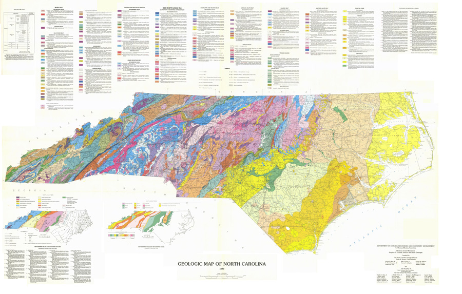
North Carolina Geologic Map (1985)
The North Carolina Geological Survey published this map in 1985. It is now out of print and available from the NCGS as a facsimile or for download. The map below is a full-resolution scanned copy of the original map, complete with the bibliographical references. It presents some minor defects due to the re-assembly of the scanned parts. Please note it is a large file.
Download full-size map in PDF format (8 MB)
Click to display; right-click and"Save Link/Target As" (Windows) to download (large PDF files do not always load correctly in some browsers)
Reference: Map compiled by The North Carolina Geological Survey, Philip M. Brown, Chief Geologist, and John M. Parker, III, State Geologic Map Coordinator in association with The State Geologic Map Advisory Committee,1985, 1 plate. Copyright: NCGS.
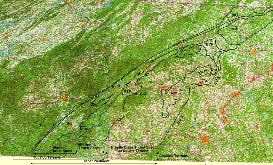
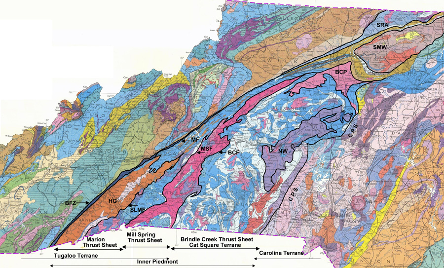
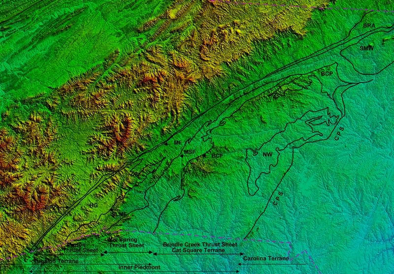
Tectonic Map of the North Carolina Inner Piedmont
Modified after Hatcher (2002), Merschat (2002), and Gilliam(2010).
Abbreviations and symbols for all three maps:
Faults: BCF-Brindle Creek. BFZ-Brevard Fault Zone. MF-Marion. MSF-Mill Spring. SLMF-Sugarloaf Mountain.
Others: BCP-Brooks Crossroads pluton. CPS-Central Piedmont Suture. HG-Henderson gneiss. NW-Newton window. SMW-Sauratown Mountain window. SRA-Smith River allochton.
State boundaries in dashed purple line.
Base: USGS 1x2 (1:250,0000) topographic map
Download full-size map in PDF format (3 MB) Download/Display medium-size map in PDF format (0.7 MB)
Click to display; right-click and "Save Link/Target As" (Windows) to download (large PDF files do not always load correctly in some browsers)
Base: North Carolina Geologic Map (1985)
Download full-size map in PDF format (1.4 MB) Download/Display medium-size map in PDF format (0.5 MB)
Click to display; right-click and "Save Link/Target As" (Windows) to download (large PDF files do not always load correctly in some browsers)
Base: 1" arc USGS NED
Download full-size map in PDF format (2.6 MB) Download/Display medium-size map in PDF format (0.8 MB)
Click to display; right-click and "Save Link/Target As" (Windows) to download (large PDF files do not always load correctly in some browsers)
References:
Gilliam, William George, "Structural and metamorphic evolution of the west-central Newton window, eastern Inner Piedmont, Burke, Catawba, and Lincoln Counties, North Carolina. " Master's Thesis, University of Tennessee, 2010,
http://trace.tennessee.edu/utk_gradthes/798.
Hatcher, R.D., Jr., 2002, An Inner Piedmont primer, in Hatcher, R.D., Jr., and Bream, B.R., eds., Inner Piedmont geology in the South Mountains-Blue Ridge Foothills and the southwestern Brushy Mountains, central-western North Carolina: North Carolina Geological Survey, Carolina
Geological Society annual field trip guidebook, p. 1-18.
Merschat, A. J., and Kalbas, J. L., 2002, Geology of the southwestern Brushy Mountains, North Carolina Inner
Piedmont: A summary and synthesis of recent studies, in Hatcher, R. D., Jr., and Bream, B. R., eds., Inner
Piedmont geology in the South Mountains-Blue Ridge Foothills and the southwestern Brushy Mountains,
central-western North Carolina: Carolina Geological Society Guidebook, p. 101-126.