Clarendon County, South Carolina, U.S.A.
Case study of a county of the Middle and Lower Atlantic Coastal Plain : geomorphology, soils, vegetation, agriculture.
The following text and the illustrations are part of a PhD dissertation. More material will be added in the near future.
Printed edition: 455 pages. 19 fig., 129 phot., 24 tabl., 2 pl.
Copyright 1985 Patrick J. Mangou
patrickmangou@usgeologymorphology.com
Sections currently available:
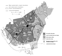
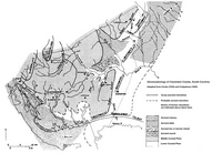
Physiographic maps of South Carolina and Clarendon County (click on link or thumbnails)
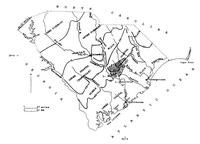
Soil map of Clarendon County, SC (click on link or thumbnail)