
Geology of Wind River Canyon, Wyoming
1 Overview
The Wind River canyon cuts through the Owl Creek Mountains. This west-northwest-trending range extends from the Absaroka Mountains' southeast end to the southern end of the Bighorn Mountains, and separates the Bighorn basin to the north from the Wind River basin to the south (fig. 1-1). Its eastern part, east of the canyon, used to be called Bridger Mountains, but now the whole range is commonly referred to as the Owl Creek Mountains.
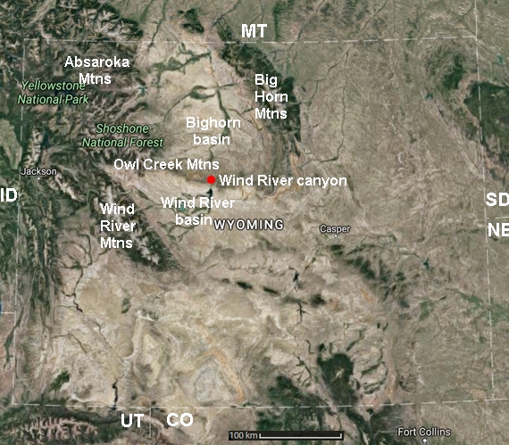
Figure 1-1. Location map of Wind River canyon, Wyoming.
The Wind River canyon cuts through the Owl Creek Mountains, located between the Absaroka Mountains and the Bighorn Mountains. Base map: Google Maps image © Google. Google and the Google logo are registered trademarks of Google Inc., used with permission.
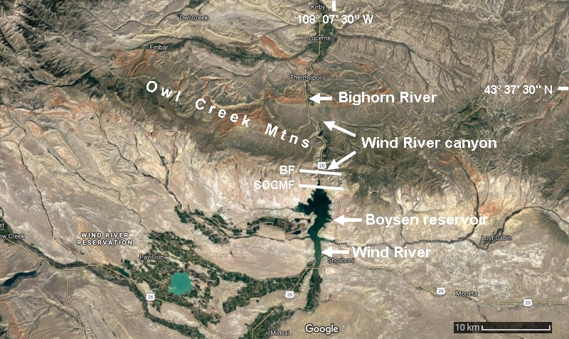
Figure 1-2. Larger-scale location map of Wind River canyon.
The Wind River first flows southeastward from the Absaroka Mountains, then northward, crosses the Owl Creek Mountains through the canyon (between the two arrows), at the end of which it becomes the Bighorn River. This unusual midstream name change comes from early explorations: explorers in Montana called the river Bighorn River, while others coming from southern Wyoming named it Wind River, ignoring it was the same stream. Eventually, both names were kept; the point where the name changes is near the northern end of the canyon and is called the Wedding of the Waters. BF: Boysen fault; SOCMF: South Owl Creek Mountains fault; both faults are indicated only in the vicinity of Wind River. Base map: Google Maps image © Google. Google and the Google logo are registered trademarks of Google Inc., used with permission.
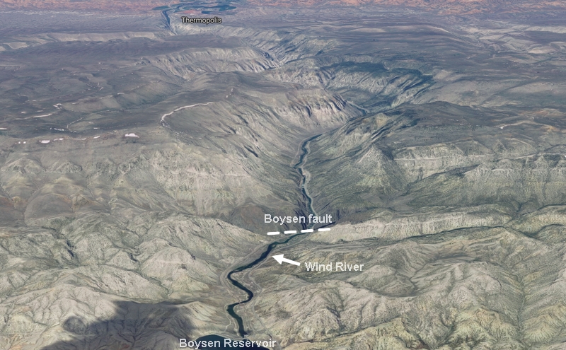
Figure 1-3. 3-D view of Wind River canyon, Wyoming.
Boysen fault marks the southern boundary of the Owl Creek Mountains and the Wind River canyon. View to the north. Base image: Google Maps image © Google. Google and the Google logo are registered trademarks of Google Inc., used with permission.
The Owl Creek Mountains originated in the Laramide orogeny (Late Cretaceous to Paleocene and probably to Eocene) when a part of the Archean basement and the sedimentary strata overlying it were uplifted and thrusted southward over the present Wind River basin, along the South Owl Creek Mountain fault (~3 km south of Boysen fault, fig. 1-2). The Boysen fault (fig. 1-2, 1-3, and 1-5) formed with the folding of the thrust front. This east-west striking fault dips southward at a 60° angle (Fanshawe, 1939) and has a displacement of ~600 m at the entrance of the canyon (Maughan, 1987). Between the two faults, erosion has removed the upper part of the thrust; the lower part exposes Cambrian and Ordovician strata overlying Triassic rocks.
Since Laramide compression uplifted the southern end of the Owl Creek Mountains, the erosion surface, which corresponds to the competent (i.e. resistant) Park City formation shows a northward dip of 6°. The underlying sedimentary layers inside the canyon dip northward at an angle varying between 4 and 9 degrees. However the Wind River has a slope of only 4° within the canyon. The displacement of the Boysen fault and the slope discrepancy between the strata and the river explain why the canyon exposes a great variety of rocks. At the river level, rocks span from the Archean in the south to the Triassic to the north.
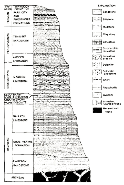
Figure 1-4. Stratigraphic column of the rocks in Wind River canyon, Wyoming.
Reproduced from Maughan (1987) with permission.
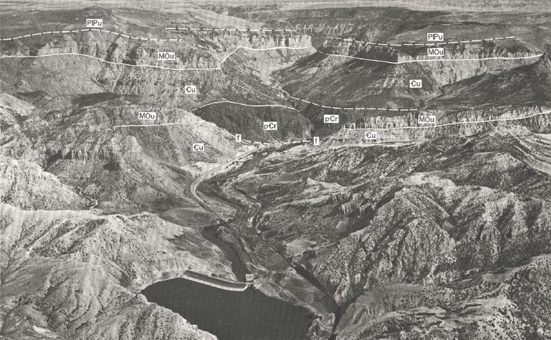
Figure 1-5. Aerial view looking north of Wind River canyon.
The Boysen fault (f-f dashed line in the center of the photo) marks the southern boundary of the canyon. P*u : Park City, Tensleep, and Amsden Formations. MOu : Madison Limestone und Bighorn Dolomite. _u : Cambrian rocks, undivided. p_r : Precambrian igneous and metamorphic rocks (geologic symbols may not render correctly in some browsers). The abbreviations used in the rest of the article will be different. Reproduced from Keefer and Van Lieu (1966). Photograph courtesy of P. T. Jenkins and L. P. House.
Next: Permian and Pennsylvanian Rocks